3 years ago
340
Views
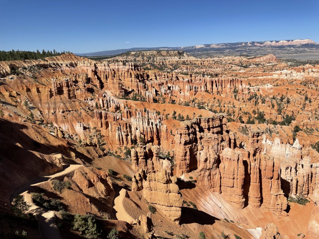
I visited Bryce Canyon National Park for a day in June 2021 with a few friends. The main thing to note about Bryce Canyon is that it is known for it's 'hoodoos' - tall, pillar-like rock/sandstone structures formed from million of years of weathering and freezing/thawing.
Bryce Canyon houses the largest collection of hoodoos in the world, with the main group of them in the Amphitheater. There is a rim trail at the top of the Amphitheater that lets you walk along relatively flat-ground to get a panoramic view of the hoodoos.
Queens Garden Trail + Najavo Loop Trail:
1) Queens Garden Trail (descent):
We hiked the Queens Garden Trail which starts at Sunrise Point (on the rim trail looking down at the Amphitheater) and snakes down to the bottom of the Amphitheater. As you gradually descend, you will see countless hoodoos and other bright red rock formations.
Distance: 1.8 miles
Elevation Change: Descend 320 feet
2) Navajo Loop Trail (ascent):
At the end of the Queens Garden Trail, it connects with the intersection of the Navajo Loop Trail. The Navajo Loop Trail starts at Sunset Point and descends into the Amphitheater, then loops back up to Sunset Point. The Queens Garden Trail ends at the mid-section of the Navajo Loop Trail, at the bottom of the Amphitheater.
Reaching this point, you can ascend the Navajo Loop Trail to Sunrise Point in two paths: (1) along Wall Street or (2) passing Two Bridges/Thor's Hammer. We ended up taking the Wall Street route which was a steep incline with stories high rocks on both sides.
Distance: 0.7 miles
Elevation Change: Ascend 515 feet
Hiking the entire Queens Garden Trail plus the Wall Street side of Navajo Loop Trail took around 3 hours total. This route gave us sweeping view of Bryce Canyon National Park while seeing some of the most iconic landmarks and hoodoos the park has to offer. If I were to visit Bryce Canyon again in the future, I would hike the Navajo Loop Trail down Wall Street, then back up Two Bridges/Thor's Hammer to get a different perspective.
3 years ago
28
Views
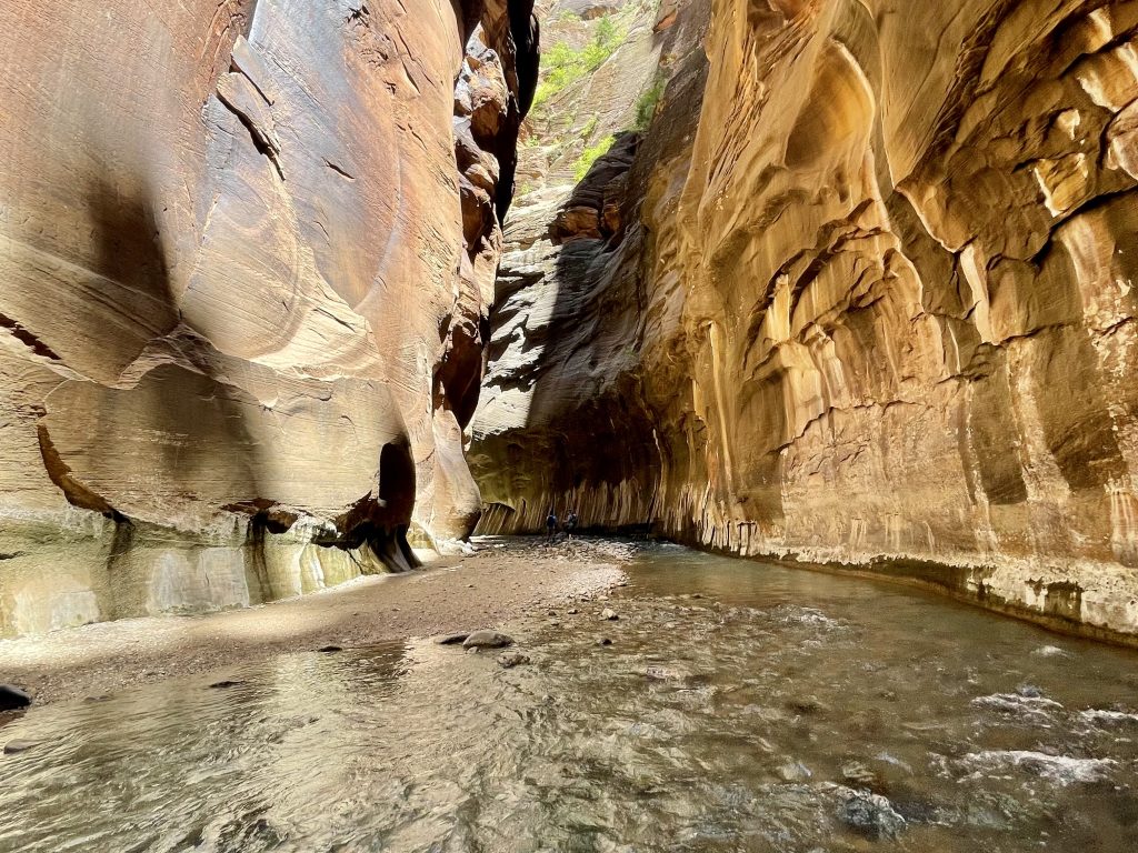
I visited Zion National Park in June 2021 with a few friends and hiked my favorite hike of all time — The Narrows.
What made the hike so memorable was the uniqueness of it — trekking in a river, knee deep in cool water on a hot summer day, with multi-storied high red canyon walls on both sides. Although the temperature that day was over 90F and dry/sunny, the coolness of walking in the shadow of the slot canyon with chilled running water over my feet and ankles made it a very comfortable hike. Most of the hike was in shin high water, however there were a few points where the water reached my waist (~3 ft high).
The Hike:
The Narrows hike from Bottoms-Up is 4 miles one-way to Big Springs, but hikers can turn around anytime. We made it to the start of Wall Street (where there is a fork in the river called the Confluence) before turning back, around 2 miles in. It took us around 1.5 hrs total to hike from the start of The Narrows to the start of Wall Street, ~3 hours total round-trip.
Getting There:
To get to the start of The Narrows trail, you need to first take the shuttle to the Temple of Sinawava. From there, walk 1 mile along the flat Riverside Trail to the end where there is a round sitting area. From there, there is a pathway to the river where you can start The Narrows hike.
Gear:
Since The Narrows requires trudging on wet, slippery rocks for miles, we rented special gear for the hike. We rented our gear from Zion Outfitters, right outside the entrance of Zion and just a short pedestrian bridge walk from the park ticket booth. The gear consists of slip-resistant rubber boots, neoprene socks, and a sturdy walking stick, all for $35. It provided the confidence to scale any wet, algae-covered rock!