1 year ago
35
Views
When you hear "National Park", you instantly think of Yellowstone or Grand Canyon. These national parks are symbolic of what it means to be a national park - grand views of prairies, rivers winding through the landscape, and sunsets that bask the scenery in orange. Yellowstone had always been at the top of my list and I finally got the chance to visit in May 2023 with some college friends. And the park delivered.
Looking back, I now view it as two types of Yellowstone:
Geysers galore
Animal safari
1. Geysers galore:
This is what Yellowstone is mainly known for. Geysers that spew hot water hundreds of feet into the air from deep within the earth. Geysers that boil just a few feet from the boardwalks, expelling sulfur reminiscent of rotten eggs. Geysers containing micro-organisms that can survive almost 200F water and produce rainbow-like colors.
While I enjoyed the geysers, they felt too "mainstream", "touristy", and "Disney-world like". They felt more like a tourist attraction with boardwalks and information panels than a majestic national park that I had hoped for. They are however very family-friendly and I would still consider them a "must-do" if visiting Yellowstone.
This brings me to point #2.
2. Animal safari:
This is where Yellowstone truly shines and what made me understand why Yellowstone is a symbol of a national park. On our last day at Yellowstone, where most of us were underwhelmed by the formulaic geyser experience so far, we ventured into Lamar Valley.
This is where a new world opened up and Yellowstone lived up to it's name. Lamar Valley is nestled deep in Yellowstone, away from the touristy boardwalks and dining halls/gift shops - land untouched. We left at 4AM so that we could get to Lamar Valley by 6AM, when most of the animals were out and about. Driving the single stretch of road in Lamar Valley, we were surrounded by valleys, lakes, rivers, mountains, prairies, and most importantly - wildlife. In just a few hours, we saw bears, wolves, bison, elk, and coyotes. I finally understood what Yellowstone stood for.
Place visited:
Old Faithful
Grand Prismatic Spring
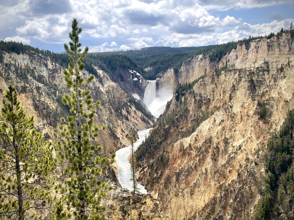
Grand Canyon of the Yellowstone
Mammoth Hot Springs
Lamar Valley
1 year ago
39
Views
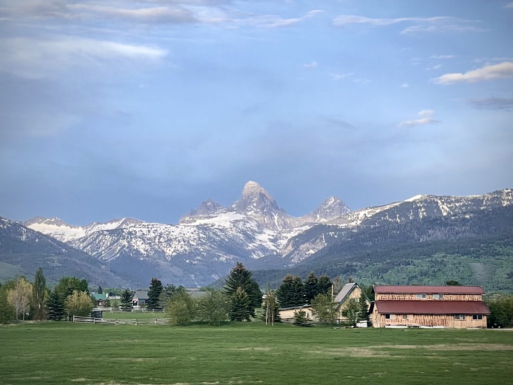
If there is one word to summarize Grand Teton National Park - it would be pristine.
For my fellow nature-lovers out there, you will not regret visiting Grand Teton. If you visualize what paintings that depict nature scenery is like, it is Grand Teton: sweeping views of snow-capped mountains, placid lakes that glitter in the sun, and waterfalls emerging from thick bushes of coniferous trees.
My friends and I visited Grand Teton in May 2023 while simultaneously exploring Yellowstone National Park and hiked around Jenny Lake, one of the main lakes at Grand Teton. If hiking around Jenny Lake, make sure to also check out Hidden Falls and Inspiration Point while on the Jenny Lake trail.
Jenny Lake Loop + Inspiration Point:
Jenny Lake Loop:
Duration: ~4 hours
Type: Loop
Distance: 7 miles
Elevation Gain: 1,040 ft
Inspiration Point:
Duration: ~1 hour
Type: Out and back
Distance: 1.8 miles
Elevation Gain: 550 ft
Another famous landmark is the T.A. Moulton Barn on Mormon Row, a famous photo-spot with the Grand Teton peaks in the backdrop.
*PS: The cover photo for this post was taken from my AirBnb bedroom!
3 years ago
74
Views
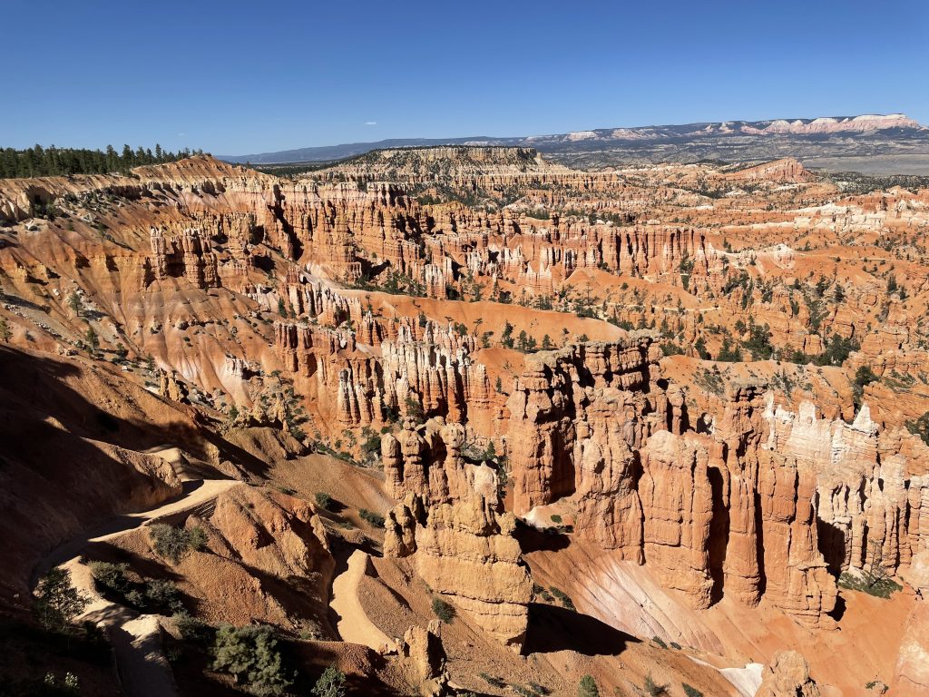
I visited Bryce Canyon National Park for a day in June 2021 with a few friends. The main thing to note about Bryce Canyon is that it is known for it's 'hoodoos' - tall, pillar-like rock/sandstone structures formed from million of years of weathering and freezing/thawing.
Bryce Canyon houses the largest collection of hoodoos in the world, with the main group of them in the Amphitheater. There is a rim trail at the top of the Amphitheater that lets you walk along relatively flat-ground to get a panoramic view of the hoodoos.
Queens Garden Trail + Najavo Loop Trail:
1) Queens Garden Trail (descent):
We hiked the Queens Garden Trail which starts at Sunrise Point (on the rim trail looking down at the Amphitheater) and snakes down to the bottom of the Amphitheater. As you gradually descend, you will see countless hoodoos and other bright red rock formations.
Distance: 1.8 miles
Elevation Change: Descend 320 feet
2) Navajo Loop Trail (ascent):
At the end of the Queens Garden Trail, it connects with the intersection of the Navajo Loop Trail. The Navajo Loop Trail starts at Sunset Point and descends into the Amphitheater, then loops back up to Sunset Point. The Queens Garden Trail ends at the mid-section of the Navajo Loop Trail, at the bottom of the Amphitheater.
Reaching this point, you can ascend the Navajo Loop Trail to Sunrise Point in two paths: (1) along Wall Street or (2) passing Two Bridges/Thor's Hammer. We ended up taking the Wall Street route which was a steep incline with stories high rocks on both sides.
Distance: 0.7 miles
Elevation Change: Ascend 515 feet
Hiking the entire Queens Garden Trail plus the Wall Street side of Navajo Loop Trail took around 3 hours total. This route gave us sweeping view of Bryce Canyon National Park while seeing some of the most iconic landmarks and hoodoos the park has to offer. If I were to visit Bryce Canyon again in the future, I would hike the Navajo Loop Trail down Wall Street, then back up Two Bridges/Thor's Hammer to get a different perspective.
3 years ago
27
Views
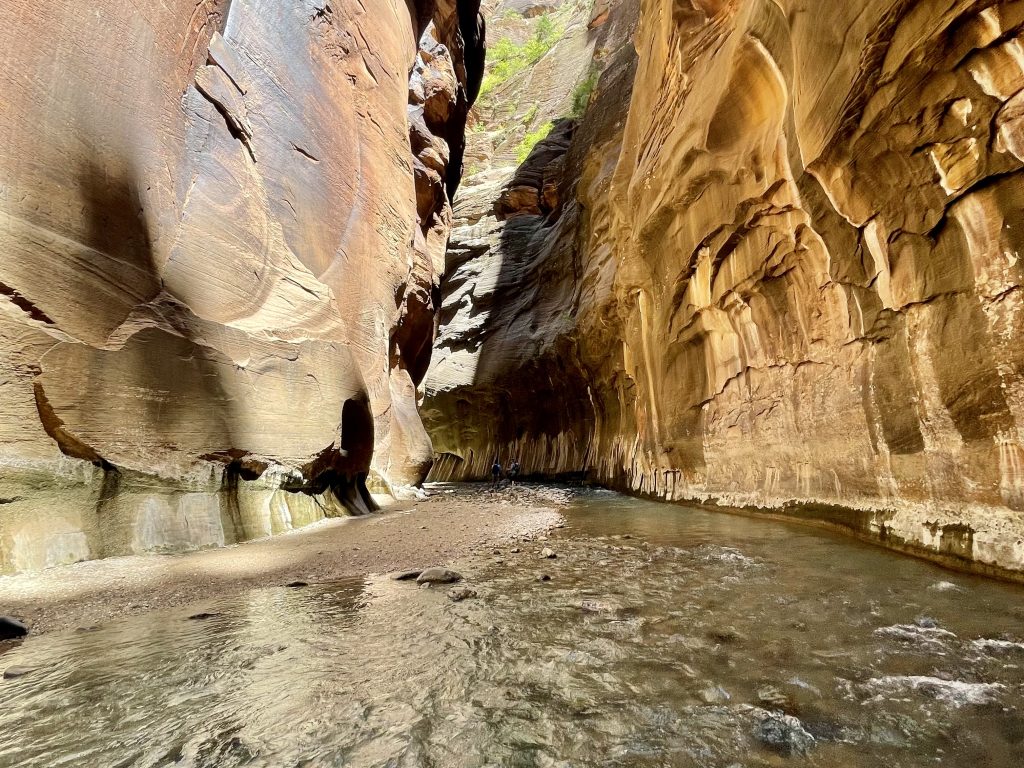
I visited Zion National Park in June 2021 with a few friends and hiked my favorite hike of all time — The Narrows.
What made the hike so memorable was the uniqueness of it — trekking in a river, knee deep in cool water on a hot summer day, with multi-storied high red canyon walls on both sides. Although the temperature that day was over 90F and dry/sunny, the coolness of walking in the shadow of the slot canyon with chilled running water over my feet and ankles made it a very comfortable hike. Most of the hike was in shin high water, however there were a few points where the water reached my waist (~3 ft high).
The Hike:
The Narrows hike from Bottoms-Up is 4 miles one-way to Big Springs, but hikers can turn around anytime. We made it to the start of Wall Street (where there is a fork in the river called the Confluence) before turning back, around 2 miles in. It took us around 1.5 hrs total to hike from the start of The Narrows to the start of Wall Street, ~3 hours total round-trip.
Getting There:
To get to the start of The Narrows trail, you need to first take the shuttle to the Temple of Sinawava. From there, walk 1 mile along the flat Riverside Trail to the end where there is a round sitting area. From there, there is a pathway to the river where you can start The Narrows hike.
Gear:
Since The Narrows requires trudging on wet, slippery rocks for miles, we rented special gear for the hike. We rented our gear from Zion Outfitters, right outside the entrance of Zion and just a short pedestrian bridge walk from the park ticket booth. The gear consists of slip-resistant rubber boots, neoprene socks, and a sturdy walking stick, all for $35. It provided the confidence to scale any wet, algae-covered rock!
3 years ago
45
Views
I visited Yosemite National Park across 2-days in June 2021 (6/7/21 - 6/8/21) with a few friends. Given it was our first time visiting Yosemite and we only had 2-days, our goal was to see as many of the famous landmarks as possible.
Day 1: Four Mile Trail
4.8 mi one-way / 9.6 mi round-trip
3,200 ft elevation gain
667 ft/mile elevation gain (going up)
~7 hours round trip
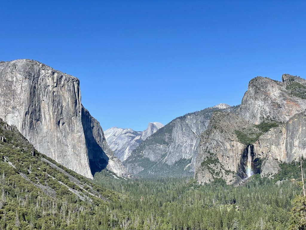
For our first day, we picked one of the more strenuous day hikes that offers views of the most iconic landmarks across the park. As you hike up Four Mile Trail, you get views of El Capitan, Yosemite Falls, Half Dome, and Yosemite Valley. This was why we chose this hike - it offered the most 'bang for your buck' in a single hike, great if you are limited on time at Yosemite and want to get the most in. I recommend starting from the Valley and hiking up since the views get more spectacular as you make your journey up.
At the end of Four Mile Trail is Glacier Point overlook, which offers stunning views of Half Dome, Vernal Falls, and Nevada Falls. It was an amazing view that made the 5 mile strenuous upward trek worth it. There is also a gift shop at Glacier Point with ice cream, snacks, and a water fountain outside (check the hours since we got there just 20 min before it closed at 5PM).
This is a strenuous hike, bring 2L of water and snacks since it takes ~4 hours going up. You can refill your water bottle(s) at the water fountains at Glacier Point.
Day 2: Exploring Yosemite Valley
For our second day, we wanted to take it lighter after hiking all of Day 1. The second day consisted more of driving around the park and taking photos at iconic spots in Yosemite Valley.
We visited in order:
Mariposa Grove
Tunnel View
Lower Yosemite Falls
Mariposa Grove is nice to visit if you have extra time, but the best spots were Tunnel View and Lower Yosemite Falls. Since we stayed in Oakhurst, we entered the park from the Southern entrance, which after a 45 min drive from the entrance to Yosemite Valley, we passed by Tunnel View (on the left-side of the road right after exiting the tunnel).
Tunnel View is a must-stop location since it offers one of the most famous views of Yosemite (El Capitan, Half Dome, Bridalveil Falls, and Yosemite Valley all in one picture frame). Lower Yosemite Falls is also very scenic while being accessible, it is a 2-min walk on flat ground right in the middle of Yosemite Valley and brings you close enough to the waterfall to get amazing pictures.